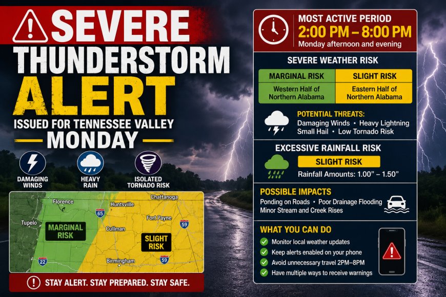
Severe Thunderstorm Alert Issued for Tennessee Valley Monday
Severe thunderstorm alert issued for the Tennessee Valley and northern Alabama on Monday, with risks of damaging winds, heavy rain, and lightning from 2–8 PM.
Severe Weather Alert Issued for Tennessee Valley & Northern Alabama: Monday Designated as Impact Day
Weather officials have placed the Tennessee Valley and northern Alabama under heightened alert for Monday, declaring it an “Impact Day” due to the potential for disruptive thunderstorms during the afternoon and evening hours. Residents are being urged to stay weather-aware as conditions may change quickly once storms begin developing.
Key Timeframe: 2:00 PM – 8:00 PM
Forecast models indicate that the most active period for storm development will likely occur between 2:00 p.m. and 8:00 p.m. on Monday. During this window, atmospheric conditions are expected to become increasingly unstable, supporting the formation of thunderstorms that could intensify rapidly as they move across the region.
Meteorologists caution that not every location will experience the same level of impact, but where storms do form, they may become strong in a short period of time.
Severe Weather Risk Breakdown
The Storm Prediction Centre has outlined a Slight Risk for severe thunderstorms across the eastern portion of northern Alabama, while areas to the west fall under a Marginal Risk.
Although this does not indicate a widespread outbreak, it does suggest the potential for scattered strong to severe storms. The main hazards include:
Damaging straight-line winds capable of downing trees and power lines
Frequent lightning strikes
Small hail in stronger storm cores
A low but non-zero chance of brief tornado development
Even isolated storms in a Slight Risk zone can produce significant local impacts, so preparedness remains important.
Heavy Rain and Flooding Concerns
Alongside the thunderstorm threat, forecasters are also highlighting a risk of excessive rainfall. Rainfall totals are generally expected to range from 1 to 1.5 inches, though some areas may see higher amounts if storms repeatedly track over the same locations.
This raises the possibility of:
Water pooling on roads and highways
Localised flash flooding in low-lying or poorly drained areas
Rapid rises in small creeks and streams
What Residents Should Do
Officials recommend that people in the affected regions remain alert throughout the day and take basic precautions ahead of time. These include:
Staying updated with local weather alerts and warnings
Ensuring phones and emergency alerts are enabled
Planning travel earlier in the day if possible, avoiding peak storm hours
Having a safe indoor location ready in case warnings are issued
Overall Outlook
Monday is not expected to be a continuous rainfall event, but rather a period of potentially intense, fast-moving storm activity concentrated in the afternoon and early evening. Conditions should gradually improve after nightfall as the weather system shifts eastward.
While the risk level is categorised as “Slight,” forecasters emphasise that even this level can still produce dangerous, localised severe weather, making vigilance throughout the day essential.